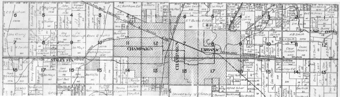
This map and the next are taken from an undated Plat Book of Champaign Co., Illinois published by W. W. Hixson & Co. There is a typewritten notation on the cover with a 1922 date. The actual date of the book has to be no later than about 1914, because it shows no tracks of the Kankakee & Urbana north of Rantoul. The K&UT tracks were extended from Rantoul to Ludlow in late 1914.
Each page of this plat book maps one township within Champaign County. The numbered squares are sections, 1 mile on each side. Throughout the county, there are roads on most of the section lines. In and near Champaign-Urbana, from west to east, the north-south roads are the modern Duncan Rd. (between sections 9 and 10 in Champaign Twp.), Mattis Ave., Prospect Ave., First/Market Streets, and Lincoln Ave. (between sections 7 and 8 in Urbana Twp.). Wright Street, the boundary between the twin cities, runs north-south through the center of Urbana Twp. sections 7 and 18. Currently, the territories of the cities of Champaign and Urbana are separate townships from the rural Champaign and Urbana Townships that surround them.
This map was formed by splicing together the maps of Champaign and Urbana Townships. The boundary, at the center of the composite map, is along First Street in Champaign, with Champaign Twp. section 12 to the left and Urbana Twp. section 7 to the right. Most of the east-west roads line up correctly, with the obvious exception of the diagonal line of the Cleveland Cincinnati Chicago & St. Louis RR, which is offset a bit.
The map shows almost all of the streetcar, interurban, and steam railroad lines in and around Champaign and Urbana, with the exception of the New Street line, part of the Third Street track, and the in-town trackage of the Kankakee & Urbana in northeast Urbana. No reason for the omissions is known.