This chapter will show the routes taken by the city and interurban lines within Urbana and Champaign. They will be discussed roughly in chronological order. Modern street and park names, where different, are in parentheses. The routes have been numbered by the author, simply for convenience; these numbers were not used by the system.
This chapter has two parts:
Part A. City Lines (immediately below)
Part B. Interurban
Routes Within the Twin Cities
Track maps are given at the end of the chapter.
At the point at which this route crossed the Boneyard Creek, just northeast of the present intersection of Springfield Ave. and 2nd St., there was a small stone arch bridge, probably built in 1860 or 1863, to carry the horsecars across the creek. Even after the effective abandonment of this part of the horsecar route, the little bridge remained. By the 1970s, it was crumbling, and was rebuilt by volunteer stonemason labor. The area around it was made into a small park in the Champaign Park District system. In 2010, this little park was incorporated into a landscaped flood control basin, and the bridge became a showpiece there. See the photos at the end of Chapter 2.
The Church Street route began in Champaign on Church Street about 1/4 mile east of Arthur Road (Mattis Ave.), i.e. about four blocks west of West End Park (Eisner Park), and went straight east on Church to Neil Street. The New Street route began in Champaign at Prospect and Green, via Green, New, Church, to Neil. Both routes then continued east via Main, Walnut, 1st South (Chester), University, to 3rd Street. At this point, the Wright St. branch continued east via University and Wright to Green Street; the John St. branch operated via 3rd Street and John to Wright, then to Green. Both routes then continued into Urbana via Green, Goodwin, private right-of-way, Main, to the Wabash crossing.
From time to time, the New Street branch was operated instead as a shuttle, from Prospect and Green to New and Church, with passengers transferring to the Church Street cars.
Beginning around 1900, some cars terminated on the east in Urbana at Main and Market (Broadway), rather than at the Wabash crossing on East Main.
In 1907, track was built on Neil Street between University and Church/Main. There were curves connecting northbound cars from Neil east into Main, and connecting southbound cars from Neil east into Main and west into Church. There was initially no curve connecting northbound cars from Neil west into Church. Northbound cars had to cross Church/Main to the north side of the intersection, then reverse direction and cross southbound to turn west into Church Street. This problem was solved in August 1912, when the fourth curve was added to the intersection, allowing northbound cars to turn directly west into Church.
Cars operated in one direction via Neil, in the other via Main and Walnut. Initially, Neil St. was used west and northbound, and Main and Walnut east and southbound. Eventually, the directions were reversed, probably in 1914.
Beginning July 1, 1909, the Green and Goodwin tracks were removed. From that date, all cars operated from Wright Street east via the private right-of-way. Also beginning on that date, the Wright Street branch was combined with the Oregon Street Line (see #7, below).
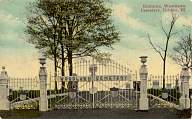
In 1909, the track on Coler Street was extended north to the gate of Woodlawn Cemetery. For a few years (at least 1909-1911), Sunday-only summertime through service was operated to the Cemetery from downtown Champaign via the John Street branch to Main and Market (Broadway) in Urbana, then via the Lake Shore Line to Woodlawn.
In 1920, summer service on the Lake Shore Line itself was extended north to Woodlawn.
The company also offered charter funeral service to Woodlawn Cemetery.
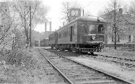
| Picture 11A-1. | |
|
|
The gate of Woodlawn Cemetery. The streetcar track came up to this point. For a funeral, the casket could ride to the end of the track, then it would be transferred to a four-wheel cart and rolled to the grave site. The family could share the streetcar with the casket, and other mourners could ride on additional chartered streetcars, as necessary. |
In 1922, with the establishment of the IC Shops Line (#14), that line took over the segment on Neil north of Church/Main. The Neil Street Line then terminated on the north at Neil and Main.
The new line was designed to run from downtown Champaign to downtown Urbana. Early in its life, the company experimented with which of the two possible Champaign routes (via Third and John or via University and Wright) would be linked to the new track in Urbana. Eventually, the University and Wright branch was combined with the Oregon Street route.
Beginning July 1, 1909, the new Oregon Street Line operated over this route: from Neil and Main in Champaign, via Main, Walnut, 1st South (Chester), University, Wright, across the UI campus into Urbana, Mathews, Oregon, Lincoln, California, Market (Broadway), to Main Street. Return was via the same route, except in downtown Champaign operating via University and Neil to Main Street. The track on Mathews, which included a passing siding, was at least partly on the west side of the street. (Around 1914, the direction of the loop in downtown Champaign was reversed.)
On January 1, 1921, the route combinations were changed. Beginning that date, the Oregon Street Line operated from Main and Neil in Champaign, via Neil, University, 3rd St., John, Wright, across the UI campus into Urbana, Mathews, Oregon, Lincoln, California, Market (Broadway), to Main Street. Return was via the same route, except in downtown Champaign operating via University, Chester, Walnut, Main, to Neil. The Wright Street branch was at this time set up as a separate route; see #13, below.
A more successful attempt at Owl Service was started July 20, 1911. It used a loop route that covered the main daytime car lines. From Prospect and Green in Champaign, it operated via Green, New, Church, Main, Walnut, 1st South (Chester), University, 3rd St., John, Wright, across the UI campus into Urbana, Mathews, Oregon, Lincoln, California, Market (Broadway), Main, to the Wabash crossing on East Main. The return trip was via Main, private right-of-way, Wright, John (into Champaign), 3rd, University, Neil, Church, New, Green, to Prospect.
At least by June 6, 1920, this had been cut back to run only from downtown Champaign to downtown Urbana. The route was from Main and Neil in Champaign, via Neil, University, 3rd St., John, Wright, across the UI campus into Urbana, Mathews, Oregon, Lincoln, California, Market (Broadway), to Main, returning via Main, private right-of-way, Wright, John (into Champaign), 3rd, University, Chester, Walnut, Main, to Neil.
This service lasted only a month or so in 1915, but was revived on September 6, 1919. It was renamed the Short Line on December 1, 1919.
This was destined to be the last streetcar line in the community, ending service on November 10, 1936.
The Church Street Line operated along Church Street from Neil west to the end of the track.
In the late 1920s [1927?], the tracks on Church Street were completely rebuilt. The company did a very good job, and the street was repaved with concrete at the same time. Some passing sidings were relocated for maximum efficiency. Unfortunately, the concrete proved to be a sounding board, and the new track, while admirable in all other ways, was so noisy that the people living on the street complained vociferously. As a result, the Church Street Line was converted to bus in [1928? 1929?]. Ironically, the track lasted until the late 1960s before the city finally covered it with asphalt. Most of the rails remain under the asphalt to this day.
The route operated from Main and Neil in Champaign via Neil, University, 3rd St., John, Wright, private right-of-way into Urbana, Main, to Market (Broadway). Return was via the same route, except in downtown Champaign, via University, Chester, Walnut, Main, to Neil.
This route was discontinued in about one month.
The route operated from Main and Neil in Champaign via Neil, University, 3rd St., John, to Wright. Return was via John, 3rd St., University, Chester, Walnut, Main, to Neil.
After discontinuance of the Urbana & Champaign via John Street Line (#11) on July 1, 1920, this was the only service along John Street until the Oregon Street route took over John Street on January 1, 1921. The John Street to the University of Illinois Line was then discontinued.
This service was subsidized by the Illinois Central (see Chapter 7). The subsidy was withdrawn June 1, 1931. As a result, buses were substituted May 18, 1932, and discontinued June 15, 1932.
This was the last city car line to be built, and the next-to-last to be closed.
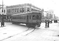
| Picture 11B-1. | |
 |
About 1909, one of the 300-308 series ITS cars loads passengers on the siding in front of the court house on Main Street in Urbana. The car had been chartered for a Sunday school class trip to Homer Park. Looks like the lad in the foreground isn't going along. Urbana Free Library Archives |
Beginning September 6, 1903, the route was extended to downtown Champaign. It used the same route as the Wright Street branch of the main city car line (see Part A, line #4 above) to downtown Urbana. Almost immediately, a terminal was built in Champaign on Walnut Street north of Main, with a wye at the intersection and a stub track north of Main Street. This opened September 19. An old city car was spotted at the end of the stub as a temporary shelter until terminal space could be prepared in the McKinley brokerage offices on Walnut Street.
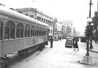
| Picture 11B-2. | |
 |
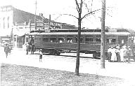
This view, postmarked 1911, is west along Main Street in Champaign. The cross street in the foreground is Walnut. The track to the north (right) leads to the depot. There is a full wye in the intersection. The interurban car approaching us on Main Street will probably turn south (to our left) and back across the intersection into the stub terminal. The street railway and interurban offices and the interurban depot shared space in the business office of J. B. & W. B. McKinley since the DU&C began interurban service between Champaign and Danville in 1903. C. U. Williams Photoette |
| Picture 11B-3. | |
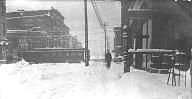 |
This view, dated December 24, 1909, is east on Main Street in Champaign looking toward Walnut, where an ITS interurban car is crossing Main through the Christmas Eve snow. The car is either heading into, or backing out of, the depot siding. |
Up to this time, the private right-of-way west of Goodwin Avenue in Urbana had been all but abandoned. In 1903, it was rebuilt for use of the interurbans between Wright and Goodwin, use beginning December 10, 1903.
When the line to Decatur was built in 1907, track was laid on Neil Street south from Church/Main. Beginning February 21, 1907, the westbound interurbans from Danville were operated over University to Neil, Main, to Walnut.
In 1909, the private right-of-way between 3rd Street and Wright was also rebuilt for interurban use. Beginning about July 1, interurbans operated via University to 3rd St. to the private right-of-way, then east to downtown Urbana.
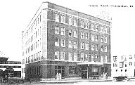
In 1913, a new station was built in Champaign on University Avenue east of Walnut Street, and the wye and stub track on Walnut north of Main were removed. Sidings were built onto the station property between the station building and the Inman Hotel, the neighbor building on the west. From January 12, 1914, local cars bound for Danville originated on one of these sidings; limited through cars from the west stopped in the street in front of the station. Westbound local cars from Danville would wye in front of the station and back into a siding. Beginning March 4, 1914, westbound local cars looped through downtown Champaign via University, 1st South (Chester), Walnut, Main, Neil, University, to the station.
| Pictures 11B-4 and 11B-5. | |
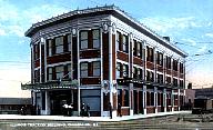 |
These two postcards show the ITS depot and its next-door neighbor, the Inman Hotel, on University Ave. in Champaign between Walnut and Market Streets. Both pictures show the alley between the buildings, which had sidings for local interurban cars. The lack of shadows in the upper picture suggests that the Inman Hotel had not yet been built, so this is a very early view of the depot. In the alley to our right (the west side of the depot), we see a self-propelled freight car. The lower picture shows a local car in the alley, waiting for passengers to board. The depot was constructed in 1913 on the site of an old mill. For the preceding several years, ITS had used the site as a freight depot. C. T. Photochrom (upper) |
 |
|
| Pictures 11B-6 and 11B-7. | |
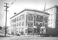 |
These two views were taken in June 1921. There were two tracks in University Ave. at this point: a through track in the center of the street, and a depot siding to the south of that track, on which the cars in these pictures are standing. In addition, there were the sidings in the alley between the depot and the Inman Hotel. Note the electric light flag on the roof of the depot. Illinois Power Co. Archives |
 |
|
About 1927, the Wabash Railroad tracks were electrified from the Wabash depot between Neil and Randolph Streets, east to the crossing of East Main Street in Urbana. This was known as the Champaign Belt. It permitted freight traffic to bypass the city streets in Champaign and most of Urbana.
When the city car lines were abandoned on November 11, 1936, the City of Champaign was eager to remove the tracks, but they were still needed by the interurban cars. In 1937, passenger traffic was changed to use the Champaign Belt, i.e., the electrified Wabash tracks, from the Wabash depot between Neil and Randolph Streets, east to the crossing of East Main Street in Urbana. This became the Danville route until the end of service in 1953. The station on University Ave. was abandoned (although it remained as offices for Illinois Power and Light Co.), as was all street trackage in Champaign. The tracks east of Wright Street on the private right-of-way were retained for coal delivery to the University of Illinois and for passenger specials to campus (e.g., football games), with trains backing in from Urbana.
| Picture 11B-7.5. | |
 |
This undated photo, probably from the 1940s, shows several interurban trains on the private right-of-way waiting to collect their passengers, probably at the conclusion of a football game. The nearest car is reported to be car 264. |
Beginning January 12, 1914, the new Champaign station was put into service. (See discussion under Danville line, #1 above.) Westbound local cars originated on a siding next to the station, and limited through cars in the street in front. They then operated over University to Neil and turned south, using the same route as before. Eastbound cars from Decatur operated north on Neil to University, then turned east to the station, with local cars wyeing and backing into a siding.
From September 3 through November 7, 1914, while repairs were being made on S. Neil St., a detour was required. Cars on the Decatur interurban line were routed through downtown Champaign and west out Church Street, down New to Green, and over a temporary track on New from Green to John, where connection was made to the permanent track on John Street. This is the only instance known of interurban cars operating on the Church and New Street lines in Champaign.
About 1927, the Illinois Central tracks were electrified from a connection to the interurban west of Duncan Road, east to the Wabash tracks at about State Street in Champaign (the Champaign Belt line). The Decatur line was then changed to use these tracks eastbound to Neil Street, then via Neil to University to the station. Westbound cars operated from the station via University, Walnut, Main, Neil, to the Wabash tracks. On August 1, 1937, when the Danville line was moved from city streets to the Wabash tracks, the University Avenue station was abandoned as a station in favor of the Wabash station, and cars operated through on the Illinois Central and Wabash tracks, bypassing downtown Champaign. This was the route to the end of service in 1955.
| Pictures 11B-8 and 11B-9. | |
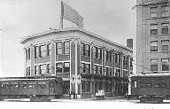
 |
IT no. 271, one of the longest cars on the roster, turns from Main Street in Champaign into Neil on its way to the electrified Wabash and Illinois Central tracks which will start it west on its way to Decatur. The date is 1936, toward the end of all street running in Champaign. Note the partially completed new city building in the background, and in the lower picture, the early model traffic light governing the intersection. University of Illinois Library Archives, News-Gazette collection |
 |
|
After abandonment of K&UT passenger service, the ITS operated freight service over the former K&UT tracks for grain elevators along the line. This service was abandoned June 17, 1927, and the track was removed.
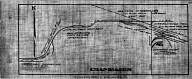
| Map 11-1. | |||
 |
The late George Fehl drew a series of remarkable maps of the Illinois Traction System / Illinois Terminal Railroad. Here is a composite of the three-page map he drew of Champaign-Urbana. All tracks are shown as of a late period in the life of the system: approximately 1930 for the city lines, about 1938 for the electrified Illinois Central and Wabash tracks. (This map is almost 2 megabytes, and may take a while to download.) George Fehl, from the Paul Stringham collection | ||
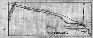
| Map 11-2. | |||
 |
This Fehl map shows the East Main Street trackage in Urbana. In effect, it is an eastward extension of the previous map. Fehl recorded every possible detail, including for example the location of each line pole. George Fehl | ||
| Maps 11-3, 11-4, and 11-5. | |||
 |
 |
 |
These maps and the next two are individual pages from a remarkable collection of maps of the Illinois Traction System in the John S. Huber collection. They are not explicitly dated, but appear to be from the late 1920s. The trackage of the Kankakee & Urbana Traction appears to be absent, which suggests a date of at least 1927 or 1928. |
| The central map of these three shows the interurban
trackage (but not all of the city streetcar trackage) from just west of Neil
Street to East Main Street in Urbana. The east-west track in the middle
of this map shows the entire private right-of-way between Third Street in
Champaign on the west and Main Street in Urbana on the east. The
footprints of several key University of Illinois buildings are shown near
the middle of this map. We can also see the sites of the Urbana Power
Plant and the Champaign Depot. The original Urbana Depot is seen in
ghostly form where it has been erased, with an arrow pointing to the new Urbana
Depot in the Flatiron Building. The maps do not seem to be drawn to
scale. The sidings near the new Urbana Depot and those in
the University area near Wright and Goodwin Streets seem to be next to one
another, although they were about a mile apart. Also, the curve of
East Main Street in Urbana seems to be exaggerated.
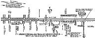
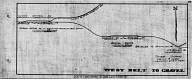
The map on the left shows the interurban tracks around the western border of Champaign. We can see the Illinois Central branch line cutting across the upper left corner of this map, with sidings and crossovers connecting to the interurban tracks. Modern Duncan Road crosses these tracks north-south immediately west of the curve in the IC tracks; that curve still crosses Springfield Avenue in west Champaign today. Going west to east, the ITS track makes two great swoops until on the east edge of this map, it comes into alignment with West John Street, via which it enters Champaign. When this area was being excavated for development in the [1980s?], the author retrieved a rather ordinary track spike, presumably discarded when these tracks were removed. The map on the right shows East Main Street in Urbana from the Wabash crossing and connection at the left, east almost to Mayview. Again, there does not seem to be any scale to the map. The mild S-curve near the words 1.0 Mile to Urbana appears to represent the point at which the tracks (looking west to east) leave the center of East Main Street and swing to the side of the road. The Poor Farm Siding was located near where the Champaign County Nursing Home is today. These details can be seen to scale on the Fehl map, Map 11-2, above. Collection of John S. Huber, copyright 2011 Larry Miller Jr. and Larry Miller III |
|||
| Maps 11-6 and 11-7. | |||
 |
 |
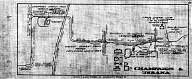
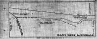
This pair of maps shows what the ITS called the Champaign Belt, made up of the electrified Illinois Central and Wabash tracks which could carry ITS traffic around the north side of the cities instead of through their center. Initially intended for freight, it came to be used for passenger traffic also, first in Champaign (allowing abandonment of the West John Street trackage), and eventually in Urbana as well. In the left map, we see at the far left edge the connection from the west, which is seen also in Map 11-3 above. The route then follows the IC east until, at about State Street in Champaign (the city streets are not shown), it connects to the west end of the Wabash branch line from Sidney. We see numerous sidings around the connections near Neil Street, including those at the Champaign Freight House. The Belt Line continues to the east, as shown in the right-hand map, crossing the IC north-south main line, ultimately connecting to East Main Street in Urbana at the lower right. Eventually, in 1937, the interurban abandoned its city trackage in Champaign, adopting the Wabash RR depots in both Champaign and Urbana for its passengers. Those depots are not shown on these maps. Collection of John S. Huber, copyright 2011 Larry Miller Jr. and Larry Miller III | |
| Map 11-8. | |||
| This map and the next are taken from an undated Plat Book
of Champaign Co., Illinois published by W. W. Hixson & Co. There is
a typewritten notation on the cover with a 1922 date. The actual date of
the book has to be no later than about 1914, because it shows no tracks of
the Kankakee & Urbana north of Rantoul. The K&UT tracks were
extended from Rantoul to Ludlow in late 1914.
Each page of this plat book maps one township within Champaign County. The numbered squares are sections, 1 mile on each side. Throughout the county, there are roads on most of the section lines. In and near Champaign-Urbana, from west to east, the north-south roads are the modern Duncan Rd. (between sections 9 and 10 in Champaign Twp.), Mattis Ave., Prospect Ave., First/Market Streets, and Lincoln Ave. (between sections 7 and 8 in Urbana Twp.). Wright Street, the boundary between the twin cities, runs north-south through the center of Urbana Twp. sections 7 and 18. Currently, the territories of the cities of Champaign and Urbana are separate townships from the rural Champaign and Urbana Townships that surround them. | |||
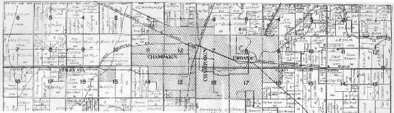 |
This map was formed by splicing together the maps of Champaign
and Urbana Townships. The boundary, at the center of the composite map,
is along First Street in Champaign, with Champaign Twp. section 12 to the left and
Urbana Twp. section 7 to the right. Most of the east-west roads line up
correctly, with the obvious exception of the diagonal line of the Cleveland
Cincinnati Chicago & St. Louis RR, which is offset a bit.
The map shows almost all of the streetcar, interurban, and steam railroad lines in and around Champaign and Urbana, with the exception of the New Street line, part of the Third Street track, and the in-town trackage of the Kankakee & Urbana in northeast Urbana. No reason for the omissions is known. | ||
| Map 11-9. | |||
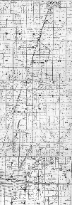 |
This map was formed from a vertical splice of the maps of Urbana, Sommer, and Rantoul Townships. It shows the line of the Kankakee & Urbana Traction from the Urbana city limit northward, beginning in Urbana Twp. section 4, then turning due north along the section line between Somer Twp. sections 27 and 28 to Thomasboro in Rantoul Twp. section 28, then running parallel to the Illinois Central RR almost to Rantoul, where it turns toward the northeast to enter Rantoul along the section line road between Rantoul Twp. sections 2 and 3, which is Chandler Street in Rantoul. The township maps north of Rantoul are not included, because they show nothing of the K&UT. Apparently, these maps predate the extension of the K&UT north of Rantoul in 1914. The K&UT trackage is identified as the Joliet & Eastern Traction, although as far as I know, the J&ET and the K&UT were never part of the same corporate structure. | ||
Computer Science Department, University of Illinois at Urbana-Champaign, Home Page